The state-of-the-art LUP4LDN tool helping to address Land Degradation wins the GEO-LDN Competition and will receive financial and technical support to transform their prototype into an operational and scalable tool.
The LUP4LDN tool (Land Use Planning for Land Degradation Neutrality) was presented at the international technology innovation competition GEO-LDN, launched by the Group on Earth Observations (GEO) Land Degradation Neutrality (LDN) Initiative in partnership with the United Nations Convention to Combat Degradation (UNCCD) Secretariat. The objective was to design and build software analytics solutions to support more transparent and well-informed land-use decisions at the local to national level across the globe. Thus, it aims to feed into innovation and collective action in order to address LDN by including subnational actors and communities in combating land degradation. The competition, guided by a specific framework, included 36 different countries and lasted 5 months, from a virtual briefing, virtual pitches (recordings: session 1 and session 2) to arrive at an award ceremony announcing the winners. From a total of 23 proposals, 3 were selected as finalists, including the LUP4LDN tool.
The GEO-LDN
competition
involved a pitch session presenting the tool, what it entails and its target
users. It also required a live presentation of the beta version. SCiO and
the team presented the live prototype to its target users such as Land use
planners, national and sub-national organizations active in land use/land
management (LU/LM) planning, policy makers, land users and research agencies,
to capture the last user-insights before its launch.
The judges of the competition acknowledged the benefits of the tool and witnessed positive feedback from users:
“LUP4LDN is a tool that greatly helps us to understand where to focus restoration activities and design scenarios for reducing land degradation” Mrs. Attia Rafla, Ministry of Agriculture, Tunisia.
After a pitch talk, a live presentation of its beta-version, the award ceremony took place at the end of the UNCCD nineteenth session of the Committee for the Review of the Implementation of the Convention (CRIC 19). The tool won first place at the competition helping encourage users to discover, use and adopt the tool!
The state-of-the-art LUP4LDN tool, aims to address land degradation, considered by the UNCCD as a growing threat to global security.
Land Degradation Neutrality (LDN) strives to achieve the SDG target 15.3 which is to combat desertification, restore degraded land via land use management and planning that results in a land degradation neutral world i.e., not net land degradation.
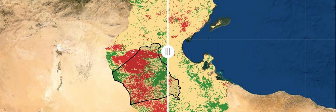
The tool has been designed to help planners focus on where to undertake land restoration efforts and which Sustainable Land Management (SLM) intervention to choose. Its target users include land use planners, national and sub-national organizations active in land use management, policy makers, land users and research agencies.
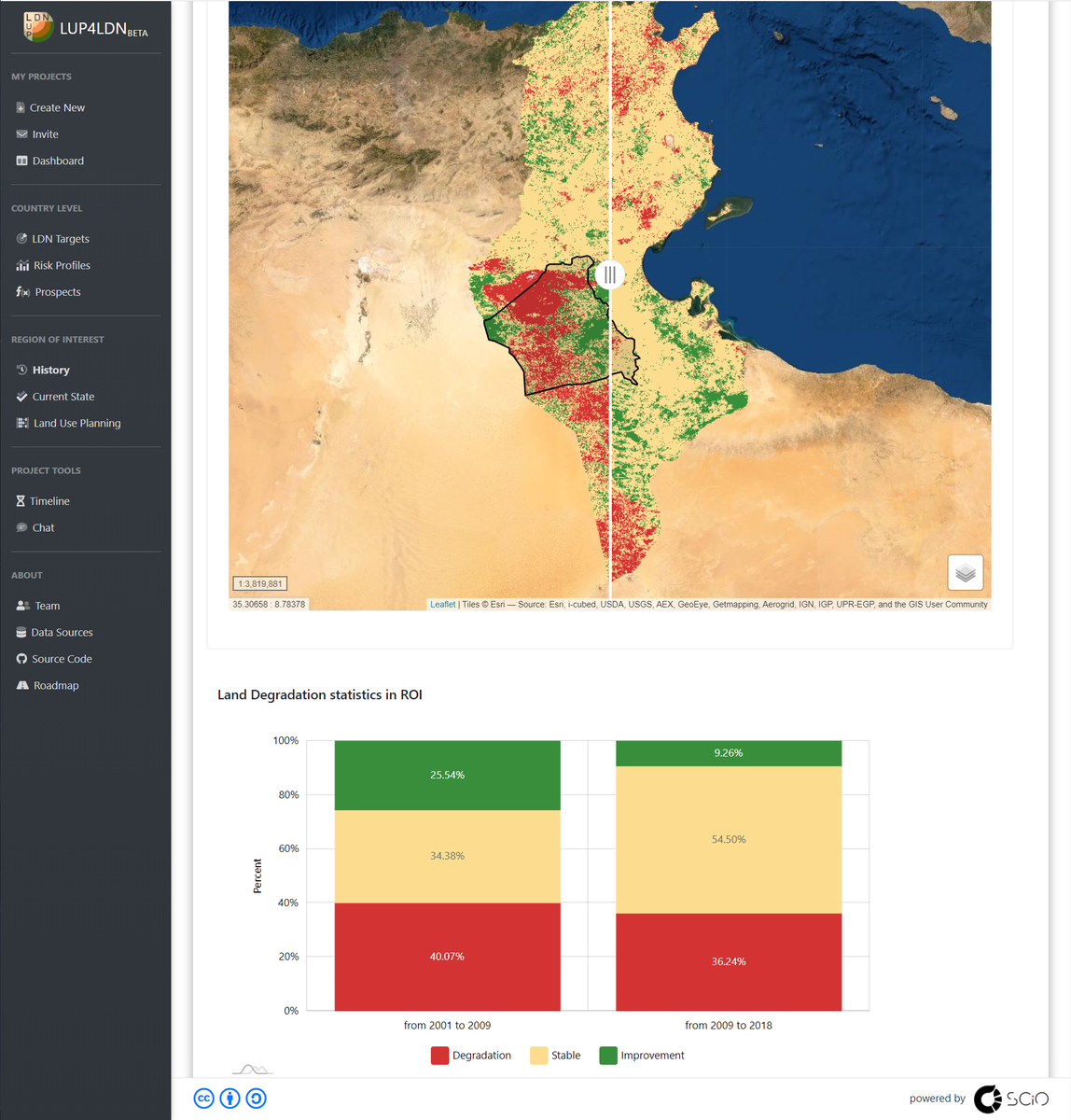
Screenshot of LUP4LDN beta-version
Using state-of-the art science the tool operates as follows:
Effectively, Teamwork makes the dream work. Starting in September 2020, a consortium was established, composed of SCiO as a leader of a team including International Center for Agricultural Research in the Dry Areas (ICARDA), the World Overview of Conservation Approaches and Technologies (WOCAT), Claudio Zucca, International land degradation and desertification expert from Università degli Studi di Sassari and the Economics for Land Degradation Initiative (ELD).
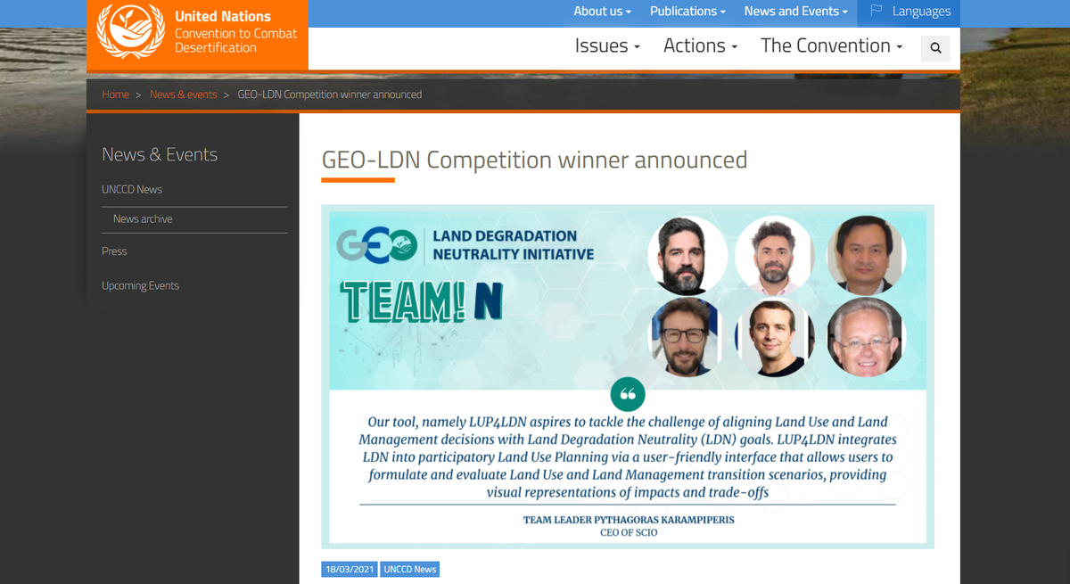
Screenshot of the UNCCD website with the announcement of the GEO-LDN competition winner
The main milestones for the tool are the completion of the tool’s functionality by May 2021, the optimization of its infrastructure in August with user consultation, scaling up to global coverage in October, and the execution of LUP4LDN piloting and capacity building activities during November and December. This will facilitate uptake of the tool, and long-term stakeholder support and use.
In case you want to get further details on the data sources used in LUP4LDN you can visit the relevant page and follow the provided links, while the complete source code is published in the project’s GitHub repository. Please find more information on the right side of the page.
Text written by:
Our site saves small pieces of text information (cookies) on your device in order to deliver better content and for statistical purposes. You can disable the usage of cookies by changing the settings of your browser. By browsing our website without changing the browser settings you grant us permission to store that information on your device.

 Italy
Italy

 Switzerland