DS-SLM en Argentina: un “pequeño” proyecto de gran impacto


Sobre SD MST en Argentina

El proyecto soporte a la toma de decisiones para la ampliación e integración del Manejo Sustentable de Tierras (SD MST). Es coordinado por la Dirección Nacional de Planificación y Ordenamiento Ambiental del territorio de la Secretaría de Ambiente y Desarollo Sustentable de la Nación, punto focal técnico ante la UNCCD.

SD MST se ejecuta de manera sinérgica con otros proyectos de implementación de prácticas de MST en el territorio financiados por el Fondo para el Medio Ambiente Mundial y el Banco Mundial, entre otros. El proyecto se ha adecuado a un objetivo trasversal a todos los componentes que es el de desarrollar, generar y poner a disposición una serie de herramientas útiles para lograr que el MST pueda ser ampliamente incorporado en las políticas públicas, correctamente monitoreado y técnicamente implementado bajo los enfoques correctos.

En este sentido, el aporte fundamental que el proyecto hará al país podría estructurarse en cuatro componentes:

  • Actualización de la línea de base de Sistemas de Uso de la Tierra y su degradación funcional.
  • Acuerdos institucionales sobre buenas prácticas de MST y compilación de experiencias y conocimiento técnico y científico.
  • Implementación modelo de  MST a escala local y esquema de replicabilidad.
  • Herramientas para el diseño de una estrategia de inserción y posicionamiento del MST a escala local.

SD MST en Argentina se destaca por su constante interacción con otras iniciativas y su inserción en las líneas estratégicas del Ministerio de Ambiente y Desarrollo Sustentable por su capacidad de dar respuesta a demandas específicas de información y conocimiento en materia de MST.

Instituciones/ organizaciones y socios involucrados

organigrama_SD_MST

En Argentina el proyecto es coordinado por la Dirección Nacional de Planificación y Ordenamiento Ambiental del territorio de la Secretaría de Ambiente y Desarrollo Sustentable de la Nación.

El comité directivo del proyecto está conformado por lo miembros principales del Observatorio Nacional de Degradación de Tierras y Desertificación.

La creación y puesta en marcha del Observatorio Nacional de la Degradación de Tierras y Desertificación  surgió a partir del culminado proyecto Evaluación de la Degradación de Tierras en Zonas Áridas (LADA), que ha sentado las bases para un sistema nacional permanente de evaluación y monitoreo estandarizada de la desertificación, incluyendo los procesos sociales y económicos relacionados, y las prácticas de mitigación, adaptación, prevención y rehabilitación recomendadas para cada situación. Este proyecto, durante casi 8 años de presencia en Argentina, ha fortalecido las capacidades instaladas en diferentes instituciones gubernamentales, académicas, científicas y técnicas del país, consolidando un equipo interinstitucional  e interdisciplinario. 

Ese Observatorio, compuesto por numerosas instituciones,  se constituye como el espacio de trabajo natural para el proyecto SD MST. Actúa como comité directivo del proyecto y también son sus miembros quienes lideran cada una de las comisiones de trabajo del proyecto. Los principales socios, en el marco del Observatorio para el proyecto, son:

  • Consejo Nacional de Investigaciones Científicas y Tecnológicas, a través de sus institutos específicos
  • Instituto Nacional de Tecnología Agropecuaria
  • Facultad de Agronomía de la Universidad de Buenos Aires
  • Universidad Nacional de Salta

Resultados DS-SLM según el marco metodológico

El sumario de los resultados por módulo está presentado en inglés. Los detalles se encuentran en los documentos adjuntos en español.

The summary of the results per module is available in English below. The details are available in the attached documents in Spanish.

Pilot site semi-arid Chaco

  1. Radio communication on SLM and training of local actors on specific SLM technologies to strengthen Peasant Production.
  2. Incorporation of the SLM technologies in the formal education system at secondary school level.

Pilot site Cuenca Arroyo Estacas

  1. Aldea Santa María and Tierra Gaucha demonstration sites with conservation terraces, forest and livestock management, for the implementation of the Soil Conservation Act (8318).
  2. Capacity building on the construction of terraces for professionals from different institutions and organizations who presented conservation projects for implementation.

For the elaboration of the LUS Map at national level, the LUS map of the drylands developed within the LADA project framework (2011) was used as a basis. In addition, the Soil Cover map (INTA 2007) was available as basic information. This map was reinterpreted and complemented with other information layers (livestock statistics by department, forest plantations map, protected areas and glaciers map) to obtain the Argentina LUS map. Mapa de Sistemas de Uso de Tierras Argentina

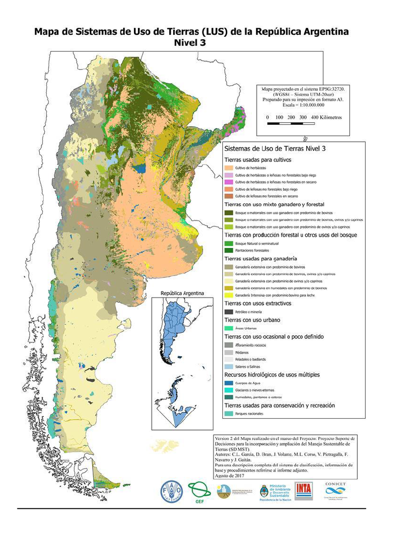
A hierarchical system, based on WOCAT, was used to define the LUS: the map with level 1 has 9 LUS, the level 2 map defines 19 LUS and level 3 has 25 LUS classes. The 1st version (not validated yet) of the LUS map of Argentina includes until level 3. For the validation, an application was developed to consult local experts from each region of the country. The application allows each local expert to have access to the map, view the polygons and enter comments about the defined LUS.

With the consultation of local experts, 60.6% (1421 polygons) of the country surface was validated. Based on the experts opinions, 335 LUS polygons (6.5% of the country's surface) were reassigned. In this way, the final map of LUS, level 3, was obtained.

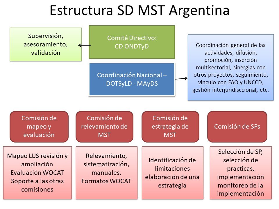
For the land degradation assessment at the national level through the local experts methodology (WOCAT-LADA QM questionnaire), the following difficulties were considered:

  • Argentina is a very large country (8th biggest country worldwide). For that reason, the LUS map has a lot of polygons (9042).
  • The LADA experience - where the QM methodology was applied for dryland areas of the country, with a lower categorization and for only a few number of polygons for each region (due to the cost associated with carrying out the validation workshops) - was very relevant, but the replication of this methodology was too expensive due to the extension of the country and its diversity of LUS.
Therefore, the QM was conducted online by experts in the pilot areas of the National Observatory of Land Degradation and Desertification and, as a complement to this, we have worked on the generation of degradation indicators using remote sensors.

Degradation indicators were generated based on the analysis of MODIS satellite images time series (2000-2014):

  • Linear trend of the NDVI index. Significant and negative trends would indicate a loss of the primary productivity of ecosystems.
  • BFAST analysis of the NDVI time series. This allows to identify the occurrence of abrupt changes, which can be associated with fires, land use changes, climatic events, etc.
  • Currently, we are working on the analysis of the precipitation-NDVI ratio at pixel level and the analysis of the residual trend of this relationship. This will allow to discriminate the areas that show NDVI tendencies due to the climatic variations of those where the causes are anthropic.

The map shows the trend of the NDVI index in the period 2000-2014. 57% of the surface showed negative trend, 5% positive tendency, and 38% did not show significant changes. In addition, the areas where the negative tendencies were more pronounced are differentiated (red color on the map).
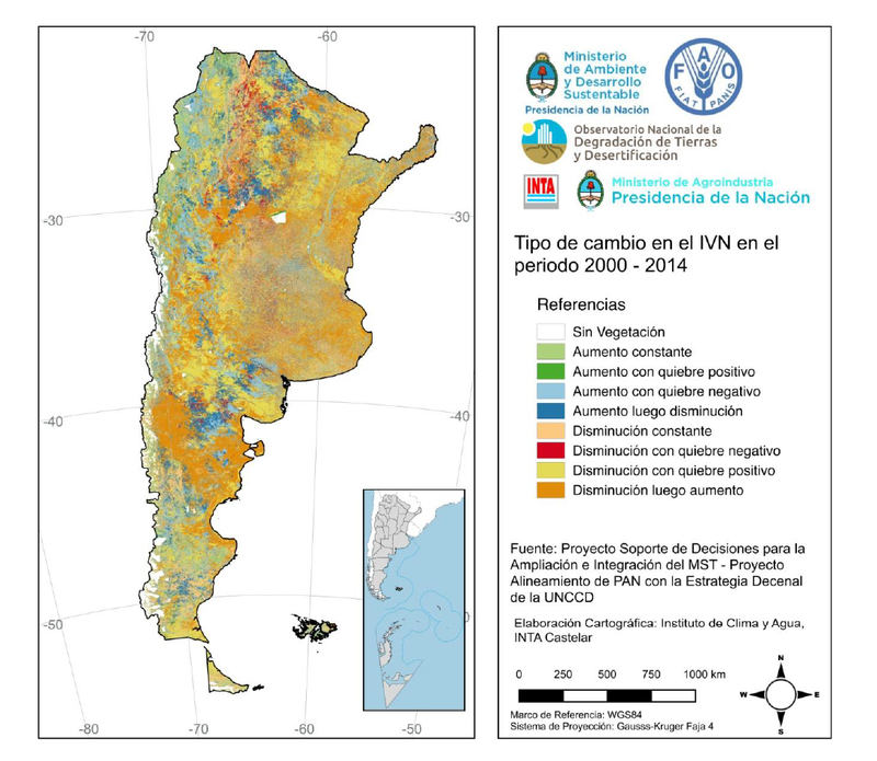
NDVI changes Argentina

From the analysis of the BFAST there are 8 types of change of the NDVI index (with or without the presence of sudden changes). This supposes an advance with regard to the analysis of the linear tendency since the detection of abrupt changes (type of change and moment of occurrence) provides information about the causes of said changes. Abrupt changes can be associated with the occurrence of clearings, fires, natural events, etc. Therefore this information helps to interpret the NDVI trend maps. In the north of the country the occurrence of strong negative tendencies of the NDVI (red color) is associated with the occurrence of changes in land use (replacement of native forest by pastures or crops). Another example from the south (Patagonia) shows the area with the most negative NDVI tendencies, which coincides with the area affected by the deposition of volcanic ash from the Caulle-Puyehue volcano (eruption June 2011).

Another indicator of land degradation that was generated at national level is the estimation of water erosion applying the universal soil loss equation (USLE). 
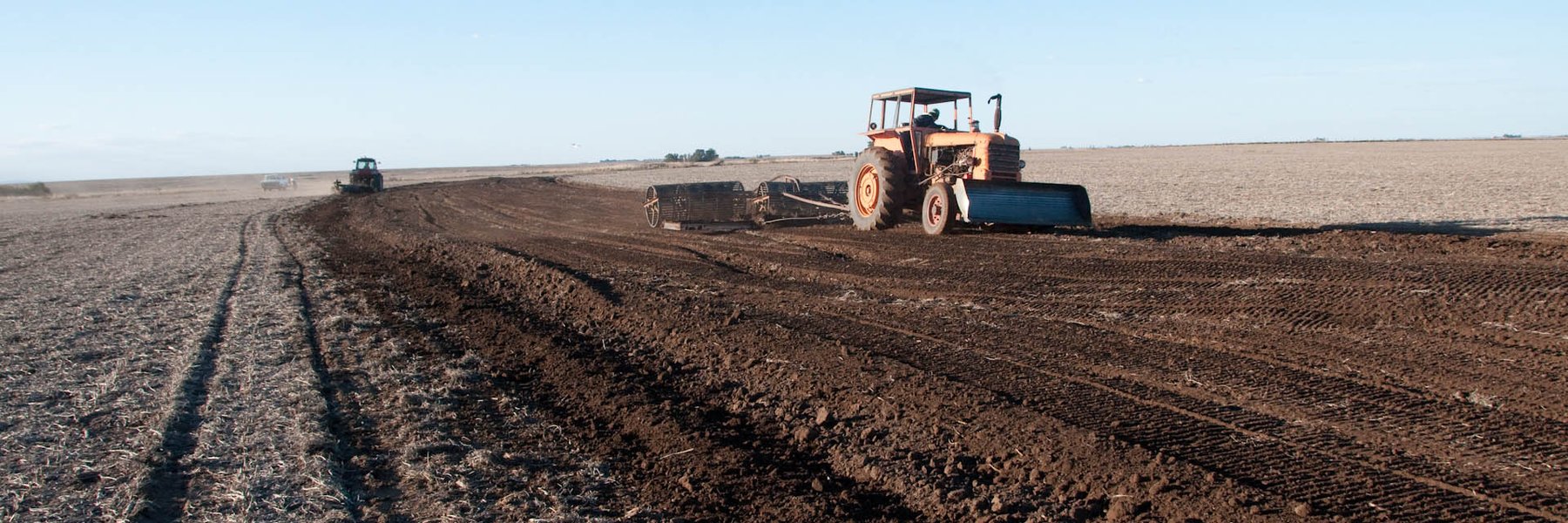
Water erosion is the most widespread process of land degradation in Argentina. The factors that control the process of water erosion were estimated and mapped and allow applying the USLE equation: rain erosivity, soil erodability, grade and length of the slope (topographic factor) and vegetation cover. In this way, potential and current water erosion at the national level was mapped.

The map shows the current water erosion rates in tons per hectare / per year in the country. The map shows on the right the areas where the current erosion exceeds the tolerance limits (between 0.5 and 10 ton / ha / year according to the region of the country). From this map appears that 26% of the national surface presents erosion rates that exceed the tolerance limits.

A web application was developed to consult local experts about LUS degradation (WOCAT-LADA QM). This survey is currently being developed were a network of experts is working in Pilot areas that make up the National Observatory of Land Degradation and Desertification. The information from the application of the QM in Pilot sites will be crossed with the indicators generated by remote sensors. This will help in the indicators’ interpretation and validation.

On February 2016, the National Observatory of Land Degradation and Desertification (ONDTyD), called for potential sites. There were 4 work proposal evaluated by the Steering committee. The Steering committee, based on the steering committee of the ONDTyD, comprises the following institutions: the Ministry of Environment, the University and research centers. The selection criteria were:

  • representativeness of the site;
  • presence of critical processes of land degradation
  • evidence of change of use
  • work team
  • linkage with local actors; and
  • institutional endorsement.

On March 2016, 2 sites were selected:

Site 1: Semi-arid Chaco salteño (grazing land, dryland)

Site 2: Cuenca Arroyo Estacas, Entre Ríos (cropland and grazing land in humid area)

    In Argentina, the project utilizes the existing structures, such as the National Observatory of Land Degradation and Desertification (ONDTyD), which continues the studies made by the LADA project and, incorporates humid areas. The project strengthens the activities carried out by the ONDTyD and the Secretary of Environment and Sustainable Development with the objective to solve the demands of the country.

    ONDTyD makes biophysical and socioeconomical assessments and the monitoring of the 15 sites in different ecosystems. The same methodology and the same group of indicators are used in each one of them. On the website of the ONDTyD you can find more details of methodologies and indicators. 

    Six good practices guidelines were produced and can be downloaded under 'Publicaciones'.

    The SLM territorial planning has not been implemented yet, however, the results (maps, management practices) from the other modules, will be used as inputs when the module 5 is implemented within the framework of another GEF project (Territorial Environmental Ordering  TEO).

      Pilot site semi-arid Chaco

      It is a site located in drylands with scarce rainfalls in summer and, characterized by a xeric forest, that is, a dry and thorny forest. Low rainfalls, high temperatures and soil characteristics are severe environmental constraints that limit forage production in the region.

      In the area, there are businessmen who are cattlemen dedicated to intensive livestock breeding, based on replacing the forest with tropical pastures. Or, by selective clearing of certain species and Desbarejado (elimination of the stratum under the trees – herbaceous and shrub).

      The traditional cattle management involves cattle under free range conditions and without fences. Therefore, due to the climatic conditions of the area and the presence of cattle, the herbaceous stratum is disappearing and producing a decrease in productivity.  With the technology called "Deschampado", the dead branches of the forest are removed and pastures are created for cattle. In this way, the clearing and loss of biodiversity is avoided, fragmentation of the passage is avoided, water erosion reduced and others.

      Pilot site Cuenca Arroyo Estaca

      The site is located in a humid area with sloping soil. It is characterized by a Prosopis forest which is threatened by clearing due to agriculture. These are lands suitable for cattle and the main crops are soy, wheat, corn and sorghum.

      Technology 1: The collector channel has a slope and grass which allows the drainage and infiltration of water. The “paño” (distance between level curves and the collector channel) decreases the slope of the soil. The crops are shown on the “paño”, following the level curves.

      Technology 2: Smooth and vegetated hill connects rivers acting as a biological corridor. This practice is more expensive and complicated for its management (machineries) as it includes leaving forest corridors in the middle of terraces with crops.

      The project allowed strengthening the existing situation. The management plan is self-managed and, the project links to the mitigation and prevention of desertification. On the other hand, there is the scientific portal with the methodologies and indicators of ONDTyD and, with the biophysical and socio-economical assessments from the 15 sites.

      More information is available here:

      www.desertificacion.gob.ar

      www.infodesert.gob.ar

        Publicaciones

        Las guías se pueden encontrar también aquí: https://www.argentina.gob.ar/desertificacion/publicaciones

        Vínculos importantes

        Personas de contacto

        Coordinadora Técnica Nacional

        Maria Laura Corso

        Dirección Nacional de Planificación y Ordenamiento Ambiental del Territorio de la Secretaría de Ambiente y Desarrollo Sustentable de la Nación

        mcorso@ambiente.gob.ar

        + 54 11 4348 8572

        Asesores Técnicos

        Vanina Pietragalla

        Dirección Nacional de Planificación y Ordenamiento Ambiental del Territorio de la Secretaría de Ambiente y Desarrollo Sustentable de la Nación

        vpietragalla@ambiente.gob.ar

        + 54 9 11 4348 8564

        Mariana Stamati

        Dirección Nacional de Planificación y Ordenamiento Ambiental del Territorio de la Secretaría de Ambiente y Desarrollo Sustentable de la Nación

        mstamati@ambiente.gob.ar

        + 54 9 11 4348 8743